


It's All Mapped Out
Creating Fictional Maps and Using "Real" Maps in Writing

I hope you’re enjoying your summer and taking precautions if you’re under extreme heat warnings. And to those in the Southern Hemisphere, I hope winter is mild.
I’m a little behind on the newsletter this month. It’s not for lack of material. Preparing two kids for college, client work, and edits for my debut is all consuming.
And speaking of my debut, I’ve just learned that my book has a new title:
THE PELICAN TIDE.
I’m thrilled as this captures a sense of place, movement, and of course pelicans. More news on the debut soon.
In this issue, I explore one of my favorite writing tools - maps. I consult and create them for settings, worldbuilding, fact checking, and more in my writing.
I’ve been fascinated by maps for as long as I can remember. Well before the Internet, maps provided me a way to imagine traveling around unknown places. Today, Google maps with its detailed street views, layers, and direction features is an integral part of my life and an essential writing tool. But more on that later.
The Wonderful World of Fantasy Maps in Fiction

Worldbuilding in speculative fiction (science fiction, fantasy, fables, and myths) often involves creating other worldly lands. Whether these places are based on Earth or in Tolkien’s imagination, Middle Earth, or on some distant planet, a fictional map can guide readers, excite the imagination, and bring a sense of reality to stories.
Check out this interactive Middle Earth map from the LOTR Project.
The first fantasy story to capture my imagination as a child was the movie, “The Wizard of Oz.” My family likes to tell embarrassing stories of how I insisted on being called Dorothy and that I would march everyone around the living with our Airedale (pretending he was Toto.) I have no memory of this - thank you baby amnesia. But that doesn’t stop the stories. I didn’t read the actual L. Frank Baum story until I was an adult.
The picture above is a promotional map of Oz created in 1914. One of its interesting features, not shown, is that East and West are reversed.
Oz, the books, the movie, and its iteration as “Wicked” the musical are ingrained in popular culture. This magical place holds a space in our collective story-loving hearts. Wicked witches, flying monkeys, munchkins (the people and the donut holes) along with tornadoes, and the sentiment there is no place like home.

Completely Random Question: What’s your favorite donut or donut hole? Or is it doughnut?
View additional maps of Oz here and here.
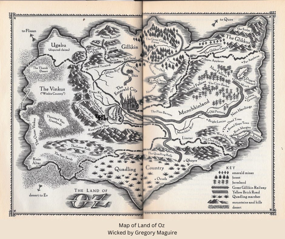
In 1995, author, Gregory Mcguire’s novel Wicked took the Wizard of Oz in a new direction. The novel, it is a retelling of the story through the point of view of the witches, Elphaba (the Wicked Witch of the West) and Glinda (The Good Witch). It too includes a map. This image below is from my personal copy of Wicked purchased in 1996 in paperback. It’s rare for me to hold on to books after I’ve read them. But some stories…
Hundreds of speculative fiction stories have maps. I feel a good map adds depth and dimension to story telling. There are too many amazing stories and maps for one newsletter, but take a few moments and check out these links where other writers have shared my map mania.
His Dark Materials
Treasure Island
The Princess Bride
Hogwarts
The Hundred Acre Woods
And more…
Star Wars
Narnia
Gotham City
Jurassic Park
And More…
Build Your Own Fantasy Map
Whether you’re creating a speculative fiction world, plotting movements in a genre fiction, or a non-fiction story, knowing where your characters live and travel can be helpful as a published visual or simply as part of your writing notes.
Consider a murder mystery where the sleuth is piecing together the killer’s movements. What escape routes are available, highways, railroad, or rivers? How about a romance where the heroine is trying to find her way across the country or the world? How long would it take?
You don’t need to be a cartographer to create your map. These websites have fantasy map making tools. (I have no affiliation with any of these sites)
Search How to Make a Fantasy Map on YouTube and dozens of videos will appear. I haven’t included any as there are too many and they vary depending on your needs.
“Real” Maps for Research
A few months ago, I took an online class, Learning from the Past from Future Learn. This is an education website where you can create an account and take hundreds of online classes for free. There is a paid version where you can earn certificates. I discovered this site during COVID lockdown. I like this site as it’s a powerful research and learning tool. I enrolled in this class when I was first interested in writing about maps.
Using maps and resources from the British library, the presenters discuss how to use maps for historical research. Here are some of the take-aways.
Consider when a map was created (time in history)
Who created it and why? Was it created with a political or financial (trade) agenda?
Can you compare two maps for accuracy?
What elements are included and why are they important? Does the map correspond to other materials?
What elements are not included? Is something hidden or is it unknown?
Is the map accurate or could it be considered a work of art?

I searched for maps in the public domain and came across this Virginia 1861 map. This map was presented without any reason. However, I know from the date, this is the start of the U.S. Civil War. Richmond, Virginia (not show) was the capital of the Confederacy. I also chose this map because the area marked Bailey’s CrossRoads and Columbia Pike is where I lived after I graduated college. I was surprised to learn how old these cities and towns are.
This map shows what areas were important to this map maker or the people who commissioned it. Off to the left is Washington (the capital), its typography is all capital letters compared to Alexandria.
Historical maps are useful:
Check the spelling of towns, cities, etc.
Locate people and communities
Piece together hidden historical facts
An example is the 1921 race riot that destroyed Black Wall Street in Tulsa, Oklahoma. (The history we were never taught.) Where was this community? This map from the Library of Congress provides some clues.

Contemporary Story Creation
Maps are invaluable for more than fantasy and history. The setting of my novel is Grand Isle, Louisiana. Due to COVID and Hurricane Ida, I’ve been unable to visit the island. But you don’t need to visit a place to write about it. We have maps! I consulted dozens of area maps to learn about the island, its streets and where it is located in relation to New Orleans, Houma, Buras, and Baton Rouge. Using the direction feature on Google Maps, I learned how far it was to drive between New Orleans and Buras, an important story plot point.
In my current work in progress, I’m writing about Saratoga Springs, New York. For this story, I need to know how far it is to Montreal and New York City. Again, Google Maps provides the answers.
Just as useful to me is this parking map that provides the names and locations of streets.

I also found this great map from Carol and Marcel’s Wedding Website. Congrats to the happy couple.

Whether you’re creating a speculative fiction story, researching a location, or fact-checking a non-fiction piece, maps have clues and answers.
Map Resources
Many universities and colleges around the world have map collections. Archives in the United States and around the world have maps. Libraries big and small have local maps and collections. When visiting an archive or a special collection, it is helpful to call in advance with your needs or make an appointment. Old maps and artifacts may need to be taken out of storage.
Online Guide to U.S. Map Collections
United States Digital Map Library
Western Association of Map Libraries
Digital Map Galleries, New York Public Library
I hope these resources start you on a path to using maps in your writing. I have much more to say about maps and directions but will save that for another issue.
If you’re looking for more worldbuilding and character development ideas,, check out the Lorteller newsletter. I started reading this a few weeks ago and it’s solid!
